
2018 WisDOT Excellence in Highway Design Award Finalist for Best Urban Project
| Type: | Reconstruction |
| Client: | City of Madison |
| KL’s Role: | Prime Consultant |
| Location: | Dane County, Wisconsin |
| Limits: | Meriter Way to Maple Grove Drive |
| Length: | 1.5 miles |
| Design Complete: | November 2016 |
| Construction Complete: | Fall 2017 |
| Construction Cost: | $10.3 Million |
Engineering Elements
- Field Survey
- Drainage / Storm Sewer Analysis & Design
- Sanitary Sewer / Water Main
- Street Lighting
- Traffic Signals
- Pavement Design Report
- Hazardous Materials Assessment
- Traffic Control Construction Staging Plans
- Transportation Management Plan
- Environmental Document (EA/FONSI)
- Section 4f Coordination
- Wetland Tracking Documentation
- Exception to Design Standards Report
- Design Study Report
- Transportation Project Plat
- Public Involvement
- Utility Coordination
- Acquiring Permits
- PS&E Submittal


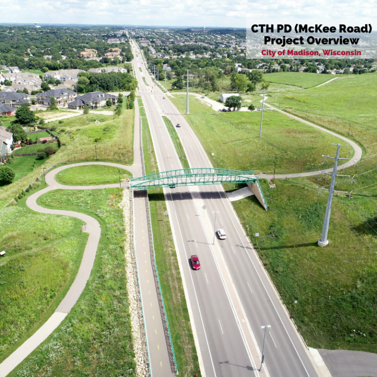
CTH PD Corridor Improvements
This project redesigned an existing 2-lane rural roadway section to a 4-lane urban roadway with median, multi-modal accommodations, and improved intersection geometrics to address safety concerns and accommodate traffic growth in this area. The corridor was experiencing a large number of crashes related to traffic congestion.
Sidewalks, a multi-use path, and bike lanes were incorporated throughout the corridor to make it usable for everyone. Curbed median with increased lighting and clearly marked crosswalks now allow pedestrians to safely cross the 4-lane road at multiple locations throughout the length of the project.
A traffic study revealed the need to signalize the intersection at CTH PD and Muir Field Road. At all of the signalized intersections, crosswalks and countdown timers were installed to increase pedestrian safety. Not only does the curbed median provide a safe refuge for pedestrians, it also houses designated turn lanes to keep through traffic moving and a protected area for vehicles waiting to turn. The Maple Grove Drive intersection was widened to allow an additional southbound travel lane across CTH PD to address traffic queuing for travelers between their homes, work, businesses, and nearby elementary school.


New Multi-Use Pedestrian Bridge
Perhaps the most interesting aspect of this project is a beautiful multi-use path bridge structure that was constructed over CTH PD. The bridge allows for direct access to the Ice Age Junction Path (Dane County Parks) and Ice Age National Scenic Trail (National Park Service and Ice Age Trail Alliance). Multiple collaboration meetings were held with these designated agencies to sculpt the new design for this environmentally sensitive Ice Age Trail Junction Natural Resource Area, which is owned by Dane County Parks. The path was designed to tie into the existing hill and preserve as much of the natural landscape as possible, including a scenic overlook location that highlights the historic glacial features on which the City of Madison now sits.
One of the safety problems with the corridor was the slope of the hill near the CTH PD and High Point Road intersection. The new design upgraded the roadway profile to reduce substandard steep slopes and to provide adequate vertical clearance for the proposed pedestrian bridge structure over CTH PD. The crest of the roadway was lowered approximately 12-ft, which substantially improved the intersection sight distance.
In order to minimize traffic utilizing other local streets and traveling through neighborhoods, the project was built one side at a time to maintain existing traffic flow. The west bound lanes were graded and lowered first, while concrete barriers were used to support the existing east bound lanes. Then the process was repeated for the other side. Keeping future traffic in mind, the bridge was designed to accommodate the potential future expansion to a 6-lane CTH PD roadway, though only 4 lanes are constructed at this time. The bridge utilizes the same decorative designs recognized on similar multi-use bridges throughout the City of Madison.

Stormwater Improvements
The widening of CTH PD also required enhancements to the Badger Mill Creek. Along with additional travel lanes comes an increase in impervious area. The box culvert near the Muir Field Road intersection under CTH PD was extended, expanding the capacity of the existing wet channel. The added capacity and realignment allow the channel to function as a stormwater treatment pond, more efficiently improving the quality and controlling the quantity of stormwater entering the Badger Mill Creek.


Complex Utility Coordination
Lowering the roadway profile to accommodate the new pedestrian bridge impacted the existing utilities in significant ways. Proactive utility coordination was a critical aspect of the project. In order to provide sufficient lead time, a relocation plan was developed early in the project for overhead high voltage electric transmission pole facilities, as well as a high-pressure gas transmission line. As a result, both facilities were able to acquire the necessary easements and perform relocations prior to roadway construction.